
LBJ Grasslands DIY-O event
Date: March 11 – March 21, 2021
LBJ National Grasslands, Decatur, TX
NOTE: CHANGE OF PLANS
New Dates due to Prescribed Burns
Welcome to the Grasslands
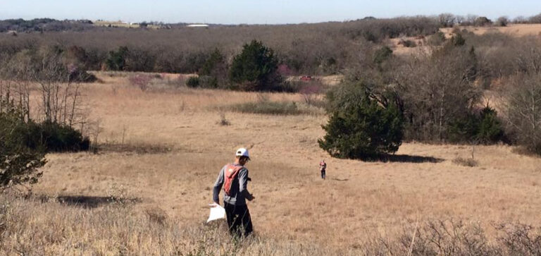
Our next event brings us to Lyndon B. Johnson National Grassland. Don’t let the name fool you. There are a lot of woods in this expansive reserve operated by the US Forest Service. The terrain is rugged and seemingly boundless, so it’s much more challenging than most of our venues. To make it more interesting, there will be some controlled burns in the area!
Do-it-Yourself Format
This event will be “orienteering without the meet” again, like we did at several meets earlier in the 2020-2021 season. The DIY format will follow state and local COVID regulations, adhere to COVID guidance from Orienteering USA, our sport’s national governing body, and hopefully, protect the health of participants and organizers. We will encourage distancing by extending the duration of the event and eliminating the need for anyone to touch equipment that is used by other runners.
The event will begin on the morning of Thursday, March 11, and extend through Sunday, March 21. You can choose any day and time you want to run. You can call USFS at (940) 627-5475 first, to be sure the burn schedule has not changed.
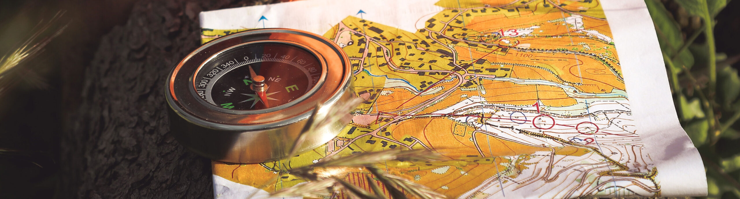
Think of it as a training event, or a permanent course that only lasts nine days. There will be no onsite organizational presence: no registration tent, no lines, no cost, no punching, no scorecards, no scoring, no DQ’s, no awards. Just orienteering fun. Bring your own water and gear. Controls will be 2-3 foot tall wooden stakes with multicolored ribbons marked with “NTOA” and the control number.
There will be NO BEGINNER (AKA WHITE) COURSE. There are several reasons for this:
- Beginners are more likely to get lost and we won’t be there to find them.
- Courses will be active for several days in a popular public park. Beginner controls must be easy to find, so they’re hung in obvious locations on well traveled trails, and therefore most likely to disappear over a number of days. Advanced controls can be hung off-trail in less frequented places.
- Beginners tend to run in groups. Groups aren’t socially distant.
- We don’t encourage groups to travel to our events on buses at this time.
- We will not have the usual training session for beginners that we have at most meets.
Beginners can participate by running on the ‘Yellow’ course with a more experienced runner (ideally a family member or leader) while following safety precaution
General info
Event Officials
Meet Director: Gene Wernette ……. Meet Director’s and Course Setter’s notes (rev 3/4)
Course Setter: Ray Janes……..Meet Director’s and Course Setter’s notes (rev 3/4)
Courses:
We’ll be offering three courses: Yellow (shortest and easiest), Brown (short but more advanced), and Red (longest and most advanced). There’s also a Score-O option, a map showing all controls with no course on it.
Classes:
N/A — No awards, so no classes.
Scoring: Honor system! Feel free to post your finishing time and perhaps a screenshot of your marked-up map in our Facebook Group after the event is over!
Scouts: A Merit Badge clinic will not be offered, but running the Yellow course will qualify for the badge. Please contact BSA Liaison Ralph Courtney for instructions on doing the required report.
Schedule & Instructions
Controls will be in the field on the morning of Thursday, March 11. The event ends at dusk on Sunday, March 21 and control markers will be removed on Monday, March 22.
INSTRUCTIONS:
- THIS EVENT IS NOW OVER. Go to the Participation Waiver page starting on Wednesday, March 10 at 5:08 p.m. Fill out the online waiver and you’ll get access to print the map for the course(s) you choose.
- Arrange for your own “runner accountability.” We recommend telling a friend or family member where you are going and when you plan to finish. Provide them with a map. Or, you may choose to meet another orienteer at the venue and run simultaneously.
- Gather your gear and don’t forget to bring your own water and map.
- Run the course. Find the controls. Enjoy.
- Check in with the person you made plans with in step 2.
- Let the course setter know if there are any control markers missing, so he can replace them.
- Optional: Post your results to NTOA’s Facebook Group. (Join us!)
- Optional: Rinse and repeat! You’re welcome to do any or all courses and come back as often as you like during the period the controls are out in the fiel3
Event fees
We’re not charging event fees for this virtual, self-serve event, but donations are always appreciated! We’re a non-profit organization.
Directions
The Grasslands DIY-O is being held on the LBJ-North Map. This is a trickier venue to find than most — consider that your first navigational challenge of the day!
From Dallas/Denton: Exit I-35N at US 380 (University Drive). West on US 380 to Decatur. Exit US 380 onto FM 730 just after the railroad overpass in Decatur. Follow directions at bottom to get to the LBJ North Map from FM 730.
From Ft. Worth: North on US 287 to Decatur. East on US 380. Left exit in 1 mile on FM 730. Follow directions below to get to the LBJ North Map from FM 730.
After taking the exit ramp off US 380:
- Turn left onto FM 730 and go 6.3 miles North to County Road CR 2360.
- Turn left on CR 2360. NOTE: CR 2360 connects to FM 730 at two places. There are brown road signs on FM 730 at both intersections that point to Black Creek Lake. If you take the first left onto CR 2360, you will soon be heading north. This route is more direct, but has more gravel road (3.75 miles). If you take the second left onto CR 2360, you will be heading west. This route is less direct, but has less gravel road (2.0 miles). The second left is the recommended route and is described below.
- Follow CR 2360 west for 1.8 miles.
- Turn West (right) onto CR 2372 and go 0.3 miles.
- Turn North (right) on CR 2461 (towards Black Creek Lake) and go 1.6 miles, taking you past the final Black Creek Lake sign.
- Turn west (left) across the cattle guard onto the Forest Service road FS 904 towards TADRA Point trailhead. (“Grasslands Bed & Barn” ranch, will be on the right before the turn.) Continue 0.7 miles west on FS 904.
- Turn right onto FS 900 at the next TADRA Pt. sign (this is less than a half mile from ‘The Mesa’ where we held many Dillo-Goat events in the past) and go north 0.7 miles toward TADRA Point.
- Park on the side of the dead-end road (FS 900A) to the west (left) less than 100 m before entering TADRA Point Trailhead area.